WWII Exhibit in Scottsville

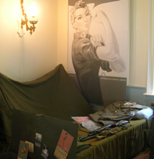
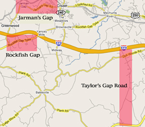
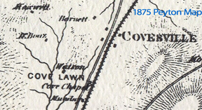
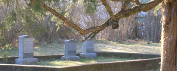
The Scottsville Museum is a hidden treasure….about 20 miles south of C-ville, but worth the trip. They have recently opened a new exhibit, titled “Small Town, Big War.” They have collected dozens of oral histories from Scottsville veterans who served in the war (conveniently transcribed and available in notebooks distributed throughout the exhibit). The photo shown here illustrates a reconstructed tent space of a U.S. Army communicator at a WWII command post.

Read more

Virginia State Fossil

I had heard about the bird (Cardinal), the flower/tree (Dogwood), the dog (American Fox Hound), and the insect (Tiger Swallowtail Butterfly), but who knew we had a state fossil ? And no surprise, it’s named after TJ: Chesapecten jeffersonius. As the first colony, it seems fitting that Virginia would be given the first fossil to be described from North America (by Martin Lister in 1687). In short, it’s a bivalve mollusc of a fossilized scallop that is over 4 million years old (dating to the Early Pliocene Epoch).

Read more

Ragged Mountain Hollers

Today’s primary roads include Route 29 (N/S) and Route 64 (E/W). In the 1860s, the railroads paved the way for a reliable N/S trajectory, setting the route for the later highway (29 south). The E/W route was originally 250 (parts of which overlap with the 18th Century “Three Notched Road”). To understand 18th and 19th Century thoroughfares, you have to ignore modern-day 64 and 29 and look to the older routes.

Read more

Rebuilt Synagogue

The Beth Israel congregation originally worshipped at the corner of Market and 2nd Street. In 1904, the government purchased the site from the congregation in order to make way for a post office. The old building materials were donated to the congregation and these materials were used to build a new structure at the corner of 3rd and Jefferson St. This building, in turn, burned in 1948, and the current building was rebuilt on the site.

Read more

Taylor's Gap

The next time you’re viewing a map of the county, look along its western edge and look for the “gaps.” Prior to construction of the Shenadoah National Park and Blue Ridge Parkway system, the Blue Ridge Mountains represented both a barrier and, through a system of highland valleys, a connection to the rest of the country. One such passage is named “Taylor’s Gap.’ Like most of the gaps, they are named after former residents.

Read more

Monticello Hotel

This historic hotel wins the competition for most renditions of Jefferson’s profile: on their plates and doormats, just to name a few. The Monticello Hotel is located directly opposite the courthouse. It was built in 1926 for $800,000. One of its claims to fame was the “world’s largest searchlight,” mounted on top of the 9-story building and allegedly visible for 100s of miles. In the photo below (taken in 2007), you can see the spot where the searchlight was mounted (at the top of the building).

Read more

Swans, Cadavers, and Taverns

As you wander north of the downtown mall, start reading the slate signs mounted on many of the brick buildings and the sometimes hidden, grey metal historic markers. This area, centered around the courthouse, contains dozens of old buildings. One famous example is the Swan Tavern, built sometime in the mid- to late-18th Century. The original structure was described in the early 1900s by Mr R Henry Carr (who was then 83 years old).

Read more

Map it! an exciting new locoogle feature!

Google Maps has recently introduced a wonderful new service: “mash-ups.” The idea harkens back to push pins (think old fashioned detective movies where they put in pins for crime sites to discern the pattern). In this case, the “push pins” are virtual, blue ones and the map base is Google Maps. Instead of colored pins, you click on the pin and a dialogue box appears. I have recently added this feature to the locohistory blog.

Read more

Hungrytown (Part I)

Where does the name “hungrytown” come from ? (a) the Great Depression when hobos visited houses in a vain hunt for food, (b) from Hungarian settlers who lived in the hollows of Virginia, © from an indigent community living in the area, (d) from a family named “Hungry”. Unfortunately, I don’t yet know the answer to this question, although A, B and C have are all part of local lore. I would suggest that “c” or “d” is the most likely.

Read more

Lions, Tigers, Hessians, Oh My!

During the Revolutionary War, the Barracks (located west of the shopping center; today a horse stable) was a prison for British and German troops captured at The Battle of Saratoga in October 1777. They were originally imprisoned by Revolutionary forces in Massachusetts, but within the year they marched 628 miles to the more hospitable climate of Charlottesville, Virginia. The term “hessian” is a reference to the German mercenaries who fought for the British.

Read more

Original Charlottesville Burial Ground

Prior to the 20th Century, there were three public cemeteries in Charlottesville: Maplewood (founded c. 1827), Oakwood (founded c. 1860), and Riverview (founded in 1887). An earlier graveyard pre-dates these, but its location is lost to the shadows of history. A rare reference to it is found in Moore’s Albemarle: Jefferson’s County (1976) who mentioned a burial ground “in a garden” off Park Street, near the First Presbyterian Church. Today it is an empty lot along an otherwise densely packed street.

Read more

Marchant's Manufacturing Building, Part Deux

Due to the wonderful comments in the earlier post, I decided to add a little more information about the Marchant Building off the corner of Dale Avenue & Harris (visible from Preston Avenue). The Sanborn excerpt below is thanks to the contribution of Bill Emory (read his original comment in the earlier post). I edited the description within the building because it would not be visible at the scale necessary to fit in this post.

Read more

Marchant's Manufacturing Company

How many times have you driven by the county office buildings/Bodo’s on Preston and wondered what the Gothic-looking mansion was originally ? I’m referring to the H.C. Marchant Manufacturing Company. In a 1906 “illustrated edition” of the Daily Progress, the plant is described as “devoted exclusively to the manufacture of overalls and coats of every grade.” Amazingly, the building contained 6,325 square feet of office space and originally employeed 75 workers.

Read more

Extraordinary Ordinaries

What is a colonial ordinary ? (a) a daily meal, consumed before dinner, (b) a second-rate menu item, © a tavern providing a meal at a set price. If you guessed “c” treat yourself to an extra dessert at your favorite modern-day inn. In the 18th Century, an Ordinary was an establishment that served meals and, sometimes, provided shelter. Ordinaries, later called taverns or inns, were spaced at regular intervals across the county so that travellers could rest and feed themselves and their horses.

Read more

Barracks Road Shopping Center

The Barracks Road Shopping Center is one of the oldest in the country, dating to 1959. To view the rest of this great old photograph of Barracks Road, see Cville Dave’s Posting on the Barracks Road Shopping Center in the 1960s. In the photo you can see the newly built shopping center, mostly surrounded by woods, with large expanses of asphalt for the “acres of free parking” that was touted in the original advertisement.

Read more

An Apple A Day...

Following on the fruit theme from the last post, what is 1,307 acres, 179+ years old, and 14 miles south of C-ville ? Answer: The Covesville Historic District. Created in 2005, the district includes 90 “primary resources” (buildings or features that have historic significance) that date between 1750 and 1954. Many of these buildings illustrate Greek Revival and Federal styles. The Peyton Map illustrates the significant structures as of 1875. Note the Cove Chapel (today the Cove Presbyterian Church).

Read more

City Orchards

How can you use maps to reconstruct C-ville history ? While not all contemporary street/geographic names are authentically historic, many reveal past events, livelihoods, and historic personages. Obvious examples include Rio Mills, Barracks Road, and J.P.A. Some neighborhoods contain dense concentrations of historically oriented street names. One example is Fifeville (itself named after the Fife family). As you drive down Cherry Avenue, look for other fruit-related street names. In the 19th Century, this area contained fruit orchards, as evidenced by street names: Apple, Cherry, Grove, and Orangedale.

Read more

Hugh Carr and Hiking Trails

Today the Ivy Creek Natural Area contains hiking trails, copious amounts of birds, and a learning center. In 1880, on this same site, Hugh Carr’s 80-acre farm, River View, contained crops, a milk cow, 4 swine, 10 poultry, and many other agricultural features. Although born into slavery around 1840, Hugh Carr worked hard after emancipation to save his earnings and invest in land in the Hydraulic Mills neighborhood (along the Rivanna).

Read more

Pigeons

Which Virginia wine goes best with squab ? One of the many valuable tools available to historic researchers are the Sanborn Fire Insurance Maps. Recently, UVA Special Collections posted the 1907 and 1920 Sanborns in a searchable format. There are 100s of forgotten treasures in these maps. One is a Pigeon Aviary, located in Belmont. [ In 1606, pigeons were introduced to North America for their homing skills and for consumption.

Read more

Ragged Mountains

What is 980 acres, 4 miles long, and contains sassafras and witch hazel ? If you guessed one of C-villes many wonderful parks, you’re on the right track. Today, the Ragged Mountains contain hiking trails, two lakes, and several historic structures. The one in the photo to the right is located along one of the original dams. Please submit a comment if you can explain why it rests atop so many courses of rocks.

Read more