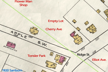
How can you use maps to reconstruct C-ville history ? While not all contemporary street/geographic names are authentically historic, many reveal past events, livelihoods, and historic personages. Obvious examples include Rio Mills, Barracks Road, and J.P.A. Some neighborhoods contain dense concentrations of historically oriented street names. One example is Fifeville (itself named after the Fife family). As you drive down Cherry Avenue, look for other fruit-related street names. In the 19th Century, this area contained fruit orchards, as evidenced by street names: Apple, Cherry, Grove, and Orangedale.

Some of these streets have disappeared since the early 20th Century. For example, Apple Street once ran east/west from 5th Street to Ridge. This short street was demolished and Cherry Avenue was built in the same general location, but running northwest to the southeast (where it turns into Elliott Avenue and passes south of the Oakwood Cemetery). The map is provided courtesy of the Geospatial & Statistical Data Center at UVA and illustrates a snippet from a 1920 Sanborn Map. The street names in red are modern, and the green line shows the rough path of today’s Cherry/Elliott streets. As you can see, Apple Street lies under today’s Tonsler Park.