Today’s primary roads include Route 29 (N/S) and Route 64 (E/W). In the 1860s, the railroads paved the way for a reliable N/S trajectory, setting the route for the later highway (29 south). The E/W route was originally 250 (parts of which overlap with the 18th Century “Three Notched Road”). To understand 18th and 19th Century thoroughfares, you have to ignore modern-day 64 and 29 and look to the older routes. Before automobiles became the primary means of transport, the slope of the road was the most important variable in selecting a path. As a result, many of the historic roads lie on top of ridges, rather than in the valleys (to prevent the loss of altitude for as long as possible). These old routes contain hundreds of ruined cabins and agricultural features. As one local resident explains, they planted their orchards (especially apples) in the hollers and their corn along the steep edges of the hillside (terraced with stone walls). The former they sold for cash, and the latter was for consumption (for people and animals). A “holler” is defined as a narrow valley between two steep hills (often containing a small creek which provided drinking water).

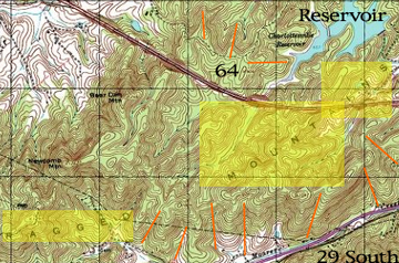
The map illustrates one small segment of Albemarle County’s historic hollers (highlighted with orange lines) and the orientation of the accompanying steep hills and waterways. This area is referred to as the Ragged Mountains and originally extended from the Reservoir (seen in the north) all the way south to Covesville.