
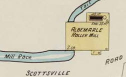
This post is a plea for information - to see if anyone knows historic details about the Albemarle Roller Mill (used by the Hartman Mill), located on a tributary of Moore’s Creek. The mill was used to process either lumber or flour. Today the site is located somewhere near Hartman’s Mill Road (between Ridge and Avon St). The drawing at the right comes from the 1907 Sanborn Fire Insurance Map and the complete image includes about half-a-dozen associated outbuilding. The Scottsville Road indicated on the map is probably located near today’s Avon Street which once connected to it.
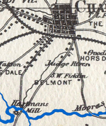
The 1875 Peyton map illustrates Hartman’s Mill at a horseshoe bend in Moore’s Creek, one mile southwest of the courthouse. Old mills needed a source of power - the mill race, powered by gravity. Hartman’s Mill ran at 100 revolutions per minute, using water from a tributary of Moore’s Creek. The “head race” (labelled here “Mill Race”) carried water from the dam to the mill site. The water wheel (at the mill) produced electricity. The “tail race” returned the water to the stream. The site would have also included millstones (circular features that were used to grind flours). Most mills also included the home of the miller.
If anyone knows the location of the mill or has any additional historic documentation about it, please post a comment.