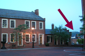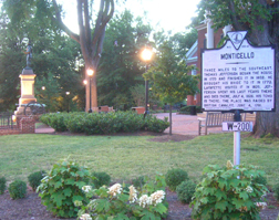

As mentioned in previous posts, the Division of Historic Resources places gray and white signs at sites of historic interest. Charlottesville has dozens of these signs, commemorating battles, individuals, historic structures, and gravesites. The idea is to draw attention to historic spots. This becomes slightly problematic when the historic sign is miles from the site itself. It’s similar to finding a sign “to I-64” on an Albemarle County road when you know darn well that the entrance ramp is a dozen miles away. If you don’t look carefully at the sign below you might assume that it commemorates the historic courthouse in the background. Or perhaps Swan Tavern (across the street). Instead, it commemorates the construction of Monticello (begun in 1770) and Jefferson’s death there in 1826 (on the 4th of July). The signs confesses that Monticello is 3 miles to the southeast. While a crow might make it within that distance, a vehicle or lost tourist would not. But if all you’re after is a scenic view, put your back to the sign and look carefully: the open hill-top seen in the photo below is Jefferson’s “little mountain.”